Browse Badges
Community
Hurricane Creek
Off-Road Trail
Pisgah National Forest, North Carolina


Adventure Badge
Premium, USA-made, Adhesive Metal Badge
$20.00
Adventure Badge
Premium, USA-made, Adhesive Metal Badge
Commemorate your experience at Hurricane Creek with a premium, USA-made Adventure Badge for your vehicle, RV, or camper.
Would you like to add a date to your badge?
Add this trail to your Adventure Log with the button below
and we'll add the year of your adventure to your badge.
Trail Information
Hurricane Creek is a moderate-to-difficult trail located just east of Great Smoky Mountain National Park in the Pigsaw National Forest of North Carolina. It comes highly recommended by many folks in the region and has a good reputation for being a great day-use trail.
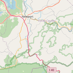
The trail is limited to one-way due to width and should be driven from west to east. Its entrance is located just off Interstate 40 at approximately 35.723312, -83.026514. Please confirm the trailhead location before your trip to ensure correctness.
On the Hurricane Creek, you'll encounter steep climbs with substantial washout. Many ruts can be dangerous if the correct line is not chosen. Moreover, any water on the trail should not be trusted, and mudholes should be treated with extreme caution as many are deeper than they might appear. The trail follows a creek (as the name implies) at the base of Hurrican Ridge, so most of the trail will present with a steep bank to the north and a corresponding drop-off to the creek to the south.
If you're interested in discovering more, check out this video from @SimplyMustGo as they share their experience on the trail in a stock Jeep Wrangler.
Basic Info
Difficulty
Difficult
Length
6.0 mi
Hightest Elevation
4010 ft
Nearest City
Hartford
Website
www.fs.usda.gov
Categories
Mountains
Views
Off-Road
National Forest
Water Crossings
